A great “river” flows through the eastern Gulf of Mexico -- the Loop Current. It sometimes pinches off to form eddies as big as Louisiana. These spinning pockets of warm water can provide the energy to boost a hurricane from a relatively minor storm to a monster in just hours inside the Gulf.
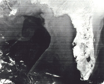 Loop Current shows as darker water in the Gulf of Mexico as seen by Very High Resolution Radiometer (VHRR) on NOAA -3 satellite. Credit: National Oceanic & Atmospheric Administration
The Loop Current develops as warm water flows into the Gulf through the Straits of Yucatan -- the gap between Cuba and the Yucatan. The current curls around Cuba and continues through the Straits of Florida into the Atlantic, forming the warm current known as the Gulf Stream.
Sometimes, though, the loop current extends farther north, into the central Gulf. As it approaches the continental shelf it curves to the east, then southward along the Florida coast, before completing the loop back at the Florida Keys. The loop brings warmer waters into the Gulf, along with abundant life.
Sometimes the Loop Current grows too big, and the northern tip of the loop pinches off. That creates a deep swirl of warm water that moves westward across the Gulf. Smaller eddies may accompany the big one.
If a hurricane moves across these pockets of warm water, their heat can cause explosive growth. In 1995, for example, as Hurricane Opal crossed a warm eddy, it blossomed from category 1 to category 4 in just 14 hours. So scientists are using satellites and other technologies to track the Loop Current and its eddies in hopes of producing better hurricane forecasts.
