Cape Hatteras. Hilton Head. Miami Beach. Galveston. South Padre.
Not only are these some of the most popular tourist destinations in the country, they’re some of the most fragile, too. Their contours are constantly reshaped by wind and waves and storms -- the fate of all barrier islands.
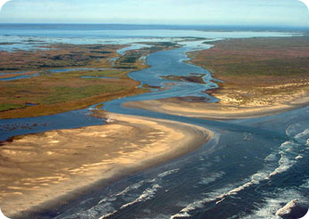 Barrier islands on the Gulf coast of Texas. Credit: Sally Morehead, UTMSI
These islands are long, narrow strips of sand that run parallel to the coastline. They’re found along all the world’s coastlines. But they’re most prominent on the Atlantic and Gulf coasts of the United States.
Many of them probably formed at the end of the last Ice Age, when rising sea levels cut off dunes from the mainland. Others formed as tides, waves, and storms piled sand in shallow areas near the shore, building them up above the surface.
A typical barrier island has a sandy beach on the ocean side, with tall dunes behind it. Grasses and trees take root in the dunes, allowing them to build even higher. Barrier flats and salt marshes form on the backside, nurturing abundant life -- from clams and crabs to birds and fish.
Barrier islands aren’t permanent, though. Waves and ocean currents constantly reshape these sand piles. Storms can scoop out big chunks of them -- and eventually wipe them away.
Hundreds of thousands of people live on America’s barrier islands, and millions visit each year. When it’s not properly managed, that human presence can damage the islands, too. And efforts to protect the islands from Nature seldom work -- what the sea gives, it can also take away.
