Great white sharks really get around. In 2000, researchers tracked one that swam almost 2500 miles, from California to Hawaii. And three years later, another great white swam from South Africa to Australia and back again in just nine months -- a round trip of almost 13,000 miles.
Scientists tracked these movements with electronic tags. The tags broadcast data to a satellite when they came to the surface.
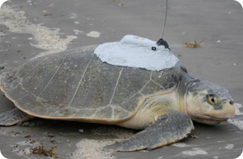 A satellite tag on a sea turtle will track where it goes between nesting seasons. Credit: www.seaturtle.org
The same technology is helping track thousands of other fish, turtles, and marine mammals and birds. The tags take scientists into the ocean depths, helping them learn about the habits of many different creatures.
There are several types of tags. Some record data for a while, then free themselves and pop to the surface. Others stay attached, and transmit every time the animal comes up for air.
The tags typically record depth, water temperature, and salinity. Some also record the animal’s temperature and other readings. With that information, scientists can plot an animal’s motions for weeks or months at a time.
The tags provide powerful tools for exploring the behavior of many different animals. Many sea turtles, for example, show up at the same beaches every year to deposit their eggs, but disappear without a trace between those times. The tags show where the turtles go.
Such information can help protect species that are threatened, and manage fishing stocks of those that aren’t -- while giving us a peek into the private lives of many of the world’s most interesting marine creatures.
