450417-new maps.jpg
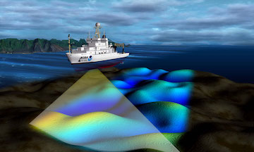
Multibeam sonar systems may be attached beneath ships' hulls to help map more of the sea floor. Credit: National Oceanic and Atmospheric Administration
The geology of the ocean floor is just as varied and amazing as that of dry land. Mountain ranges stretch across thousands of miles, trenches plunge miles deep, and cracks in the crust look like the furrows of a plowed field.
Yet not only is much of that landscape unseen, it’s unknown. Only a small fraction of the ocean floor has been mapped in as much detail as the land. And large areas have barely been peeked at.
But an international organization is trying to change that. Its goal is to map the entire ocean floor in high resolution by the end of 2030. The group is known as GEBCO -- the General Bathymetric Chart of the Oceans. It plans to take a two-pronged approach to the project. One approach will try to obtain ocean-floor maps compiled by governments, companies, and academics around the world that haven’t yet been made public. Just putting together all the work that’s already been done would greatly improve ocean-floor maps.
The second approach would be to go out and map all the ocean floor that’s still poorly understood. In addition to dedicated research vessels, the project might attach bottom-scanning sonar to ships that don’t normally do such work, such as cargo ships and icebreakers. So every time a ship crossed the ocean, it would be “pinging” the ocean floor all the way.
GEBCO doesn’t have the funding for the project yet. But it is taking some early steps toward mapping the ocean floor -- a project that eventually may allow us see all the wonders at the bottom of the sea.
