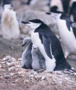
Chinstrap penguins may be contenders for the title of “world’s greatest power nappers.” A recent study found that penguins that are watching over their eggs or chicks nod off more than 10,000 times a day—for an average of just four seconds per nap.
Chinstrap penguins live in Antarctica and nearby islands. Adults stand about two and a half feet tall, and weigh up to 10 or 12 pounds. They get their name from a thin line of black feathers that look like a chinstrap. They return to their nesting grounds every October or November—hundreds of thousands or more in a single colony.
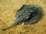
Did you see the headlines earlier this year suggesting that a round stingray at a North Carolina aquarium may have become pregnant by one of the male sharks in her tank? As cool as the idea may sound, it is impossible. Sharks and stingrays are somewhat related (about as close as a human is to a mouse), but about 300 million years of evolution separate the species. Genetically, they’re too different to reproduce successfully. But the reality of what probably did happen is just as cool: it’s possible that Charlotte, the solo stingray, cloned herself.

