Measuring the average depth of the world’s oceans seems like a straightforward problem. Drop a line over the side of a ship, measure how much line spools out, and repeat at locations across the globe. And in fact, oceanographer John Murray did just that in the late 19th century. He came up with an average of 12,457 feet. And it was a remarkably good result — it varies from the most recent measurement by just three percent.
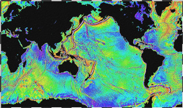 Mapping of the ocean surface from orbiting satellites can give scientists information about ocean depths. Credit: National Oceanic and Atmospheric Administration
But measuring ocean depth is trickier than it seems because we can’t actually see the ocean floor. Some of it is smooth and flat, but some is covered with tall mountains and deep canyons. Ship-based sonar provides the most accurate map, but only a fraction of the oceans have been mapped by this technique.
The most recent study used another technique: radar mapping of the ocean surface from orbiting satellites. Mounds of water build up above mountain ranges, with troughs above valleys. A little math converts those mounds and troughs into a rough map of the ocean floor. From that map, researchers got the most accurate reading of the ocean depth to date: an average of 12,081 feet.
And a little more math — multiplying the average depth by the ocean’s surface area — reveals the total volume of water in the oceans: 320 million cubic miles. That number could change in the coming years and decades as the result of Earth’s changing climate. So scientists will be keeping an eye on it for changes — from ships at sea, and from satellites high above.
