For the most part, the coastal regions of Texas and Louisiana are flat and featureless. The coastal plains slope gently upward from the Gulf of Mexico, with few hills and canyons to break up the flat terrain. And that trend continues far out into the gulf as well.
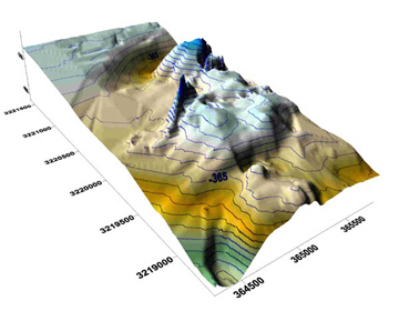 Bathymetry is a measure of the water depth relative to sea level. Credit: National Oceanic and Atmospheric Administration
About a hundred miles offshore, though, the contours begin to change dramatically. Maps compiled from decades of measurements show hills, ridges, and canyons that make the Gulf floor look more like the Badlands of South Dakota than the Great Plains.
In part, those features are the work of thousands of years of changing sea level.
During the last Ice Age, the surface of the Gulf of Mexico was hundreds of feet lower than it is today, so the coastline extended far seaward from its current position. As the climate warmed, though, the water level rose, often nearly stabilizing for centuries at a time. The Mississippi, Rio Grande, and other rivers built new deltas and carved channels, and wind and waves built new barrier islands.
As the sea level rose, coral reefs grew on submerged barrier islands, salt domes, and other features. When the level rose again, the corals mostly died out. Reefs continued to build only on the Flower Garden Banks, where conditions were just right, and living reefs are still found in the Flower Gardens today. Reef building also gave us more than 40 other named banks.
The Gulf floor is still being reshaped today, by rivers, storms, and even people — sculpting a new landscape beneath the waves.
This episode of Science & the Sea was made possible by Texas Sea Grant.
