271312 bird radar.JPG
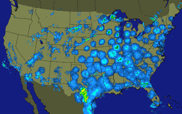
Radar captures this snapshot of bird migration across the eastern and central United States on April 28, 2004. Credit: USGS
Every spring, millions of visitors flock to the coasts of Texas and Louisiana. They gorge themselves for a few days before many of them head north — often all the way to Canada.
These visitors are birds — dozens of species that cross the Gulf of Mexico to reach their summer breeding grounds. And scientists and birdwatchers alike get early notice of the arrivals from radar — the same stations that are used to track the weather.
Scientists have used radar to track birds for decades. But it didn’t become a particularly helpful tool until the advent of Doppler radar in the early 1990s. It not only shows where the birds are, but it shows which way they’re moving and how fast. And because it’s digital, the data can be archived for later study.
The observations have helped answer some basic questions about migrations from Mexico and Central America. They’ve confirmed, for example, that many species fly over the open Gulf instead of staying over land. They’ve also revealed the size of the migrations and how they’re affected by weather, and where the birds are most likely to congregate when they reach the United States.
Knowing when and where the birds will arrive can help with conservation efforts along the Gulf coast. For example, it can identify areas where development would be likely to deprive the birds of the habitat they need to rest and recharge for the trip north. So using radar to track migrating birds can help coastal communities make these visitors welcome for a long time to come.
