Wake Island is a tiny American presence in the eastern Pacific Ocean. Best known as the site of some fierce fighting in World War II, it covers just three square miles. Yet it gives the United States dominion over more than 150,000 square miles of the Pacific – from the fish that swim beneath the surface to the minerals beneath the ocean floor.
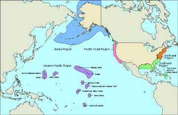 This map shows the U.S. exclusive economic zone. Credit: National Oceanic and Atmospheric Administration
All nations have total control over all the waters extending 12 nautical miles from their coastlines. But until 1982, individual countries claimed economic control of varying areas of the oceans beyond those territorial boundaries.
That year, the United Nations adopted a new law of the sea that defines the Exclusive Economic Zone, or EEZ. It gives nations economic control over waters out to 200 nautical miles. Within that zone, a country controls the water itself, the fish, and the minerals below the ocean floor. It even controls the production of energy from ocean currents or winds.
The control isn’t exclusive – other countries can sail through or fly over an economic zone. And where two zones overlap, countries have to work out the details on who controls what. Not surprisingly, that’s led to a lot of disagreements.
The United States has the world’s largest EEZ. It covers about four-and-a-half million square miles. That includes the coastlines of the Lower 48 states, Alaska, and Hawaii, plus Puerto Rico, the U.S. Virgin Islands, and several islands or island groups in the Pacific – dots of land that give America sway over large regions of the ocean.
