When Benjamin Franklin crossed the Atlantic Ocean, he was no idle passenger. Among other tasks, he plotted water temperatures by dropping a thermometer over the side of the ship. That helped him devise an accurate map of the Gulf Stream, the current of warm water that flows along the Eastern Seaboard and across to Europe.
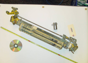 Nansen bottle with a metal messenger (the small metal weight above the bottle) and a compact disc for size comparison. Credit: National Oceanic and Atmospheric Administration
Scientists are still measuring ocean temperatures today. Like everything else in modern life, though, it’s all high-tech. And the stakes are a little higher than in Franklin’s time: not just plotting currents, but understanding how the oceans are responding to our planet’s changing climate.
Oceanographers used Franklin’s technique for many decades. After that, they began pulling up seawater in buckets and measuring the temperature on a ship’s deck, or having ships measure the temperature of the water they used to cool their engines. And for deeper water, they used Nansen bottles, which housed a thermometer in a special container.
In recent decades, mercury thermometers have given way to electronic ones. These instruments can be deployed on buoys that float with the currents or that are moored to the ocean floor. Their readings are accurate to within a fraction of a degree.
These instruments provide a look at temperatures at specific spots across the globe. To get a picture of the entire globe, scientists use satellites. Their instruments measure the heat energy radiated into space — providing an instant temperature map of a wide swath of the ocean surface.
