710924 composite_full resolution.jpg
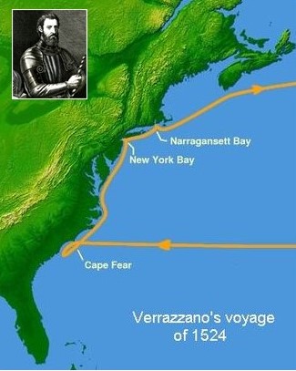
Italian navigator Giovanni Verrazzano sailed to the New World in 1524, looking for a route to Asia. As the first European to set sights on New York Harbor and Block Island, he helped map the eastern coastline of North America. Map credit: Matthew Trump, CC BY-SA 3.0, Inset credit: F. Allegrini
One of the great quests of the 16th century was to find a northwest passage—a shortcut from Europe to Asia. Such a route would go through or above the lands of the New World. No one ever found it because there isn’t one. But the search gave European mapmakers and scientists a lot of information about the North American coastline.
One example was a search that reached the coast 500 years ago. Italian navigator Giovanni da Verrazzano convinced the king of France to sponsor a search for the northwest passage. The expedition set sail in January of 1524. It reached the coast in March, near Cape Fear, North Carolina.
Verrazzano sailed south for a while, but stopped before he reached Florida, which was claimed by Spain. He then headed north. Over the next few months, he cruised past present-day New York, New England, and toward Canada.
During that time, he and his crew became the first Europeans to see what are now known as New York Harbor, Block Island, and Narragansett Bay, Rhode Island. Verrazzano also bestowed Old World names on many of the features he saw.
His accounts of the journey helped mapmakers begin to craft maps of that part of the American coastline. Verrazzano also became convinced that everything he saw was part of a single vast continent—with no way through it.
Verrazano visited the New World two more times. He was killed during an encounter with the natives of one of the Caribbean islands during the last visit, in 1528.
